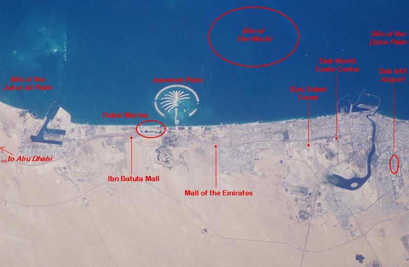
Dubai Marina vis-à-vis Greater Dubai
......................................click map to enlarge
Dubai Marina (encircled area left of the Palm) is part of what is sometimes referred to as the New Dubai. The Dubai Marina borders Sheikh Zayed Road, Dubai's main artery, which runs the length of the coast to Abu Dhabi. (SZR can be faintly seen in the map, roughly 1-3 km inland.) Dubai's most important sites and landmarks line this highway.
Starting just left of Dubai Marina is Ibn Battuta Mall, the largest shopping mall in Dubai, until Mall of the Emirates (next on the map) opened in September 2005. This mall features the world's largest indoor ski slope. The mall will keep its title as Dubai's and the Middle East's largest until the Mall of Dubai opens at the Burj Dubai Tower around 2008.
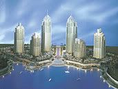
 The Burj Dubai Tower, 18 floors and counting, will be the tallest building in the world when completed. It is to be surrounded by smaller towers and a new development called Old Dubai. Further along the highway is the former singnature landmark for Dubai, the Dubai World Trade Center, built in 1979. Between the Burj Dubai and the WTC is a wall of towers lining either side of SZR (see photo). If there really is such a thing as New Dubai and Old Dubai, then this area might be referred to as Dubai Now. It's the most happening part of the city--traffic wise!
After the World Trade Center, Sheikh Zayed Road fans out into different branches depositing drivers into the different districts of the real old Dubai. The large waterway, known as Dubai Creek, will be extended at some point, winding its way back down to SZR and ending at what will be called Buisiness Bay--sure to be another claimant for the title of New Dubai.
At far right on the map above is the Dubai International Airport. When traffic is light (pre-dawn hours and Friday daytime) it takes only 20 minutes to travel between the airport and Dubai Marina via SZR. Under normal traffic conditions it takes about 40 minutes.
Offshore are the island developments. The only one pictured above is the Jumeirah Palm. A more photographic current map would clearly show the Jebel Ali Palm and parts of The World and Deria Palm. Next in line to rise from the Arabian (aka Persian) Gulf is the Dubai Waterfront, which will be a landmass in the shape of a large crescent moon, partially encircling the Jebel Ali Palm. The Waterfront will reach inland, stretching along the banks of a river--to be constructed. This will complement the soon to be dug out Jumeirah Lake (opposite Dubai Marina on SZR), Jumeirah Islands (already visible on newer maps) and a host of other water-themed developments.
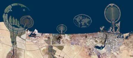
Dubai Waterfront, Jebel Ali Palm, Jumeirah Palm, The World & Deira Palm.
Still more, there will be the massive Dubai Land project and neighboring developments that will fill most of the inland desert area below what is now the present city of Dubai. Complementing all of this will be several new and expanded expressways, interchanges, overpasses, bridges and tunnels (some already completed and most presently under construction), as well as a two line metro with connecting monorails, tram lines and a building-to-building personal transport system, along with new bus lines (including the world's first a/c bus stands), water taxis and ferries, and last but not least--to complement the presently under-construction massive Dubai Int'l Airport's Terminal 3--a whole new international airport at Jebel Ali.
What exists of Dubai today is about one third of what will exist in the near future and about 1/3 of all the new construction is taking place now! As a result, the metropolis is presently a mess, but what is yet to be seen will be quite simply amazing. It's easy to be skeptical that any city or state could pull off such an ambitios plan, but when one visits Dubai and sees all the towers rising--currently over 200--the land reclamation in progress and all of the roadworks, it is hard to remain skeptical.
Return to site later for a better quality map. Closer and more detailed maps of Dubai Marina visible at earlier posting.
See latest DM Map posts. Go to Dubai Marina Communities or MAG 218 Community homepage.
posted by B.D. at
8:37 AM
![]()
![]()


0 Comments:
Post a Comment
<< Home